
A previously undocumented, well-worn, and faded, but intriguingly attractive manuscript map sold at Swann Auction Galleries in New York in 2006 (Fig. 1). “A New and Correct MAP of the Province of North Carolina drawn from the Original of Col. Mosely’s [sic] Survey by J. Cowley, London 1737” had no history or provenance associated with it at the time of the sale (Fig. 2).[1]
![Fig. 1: “A New and Correct MAP of the Province of North Carolina drawn from the Original of Col. Mosely’s [sic] Survey by J. Cowley, London 1737.” Ink on paper; HOA: 22-1/2", WOA: 28". Private collection.](https://www.mesdajournal.org/wp-content/blogs.dir/23/files/mcnamara-2012/mcnamara-fig-01.jpg) Figure 1 |
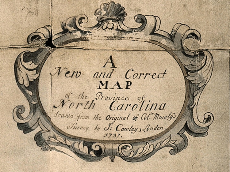 Figure 2 |
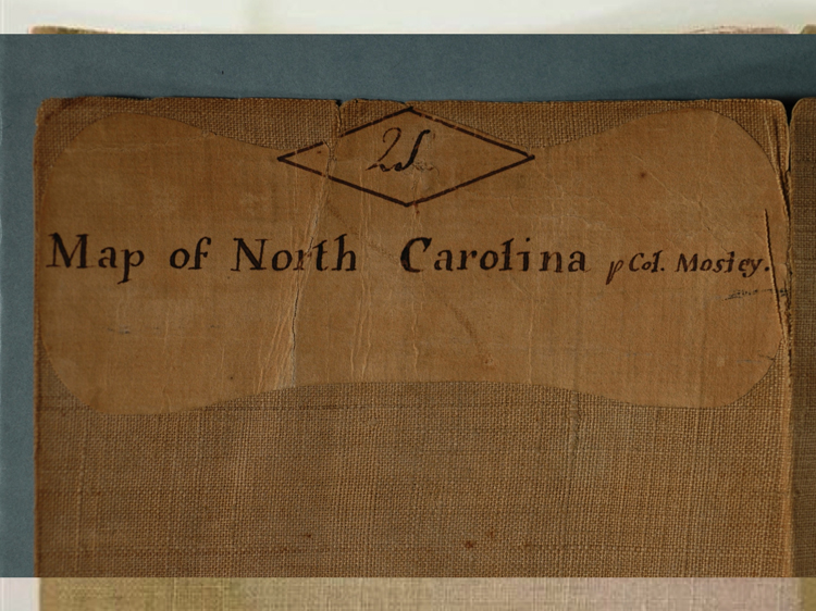 Figure 3 |
Drawn with pen and ink on laid paper, the manuscript map was hand-colored, mounted on linen, and measured approximately 28” by 22.5”. Adhered to the back of the map was a label with the notation, “2S / Map of North Carolina pCol Mosley [sic].” (Fig. 3). The paper was embossed with one of the same watermarks as paper used by Mark Catesby for his highly regarded Natural History of Carolina, Florida, and the Bahama Islands issued between 1733 and 1745.[2] The map appeared to have been repaired more than once, and the linen upon which it was mounted probably dates to the early nineteenth century.[3] The amount of wear evident on the map suggests that it was heavily consulted by its owners for many decades, but questions concerning its historical significance, who commissioned it, and for what purposes were unanswered. This article attempts to answer those questions.
Colonial North Carolina Maps
Period maps reflect the history and politics of their times. They reveal what people knew and believed about the geography of an area and convey specific information the mapmaker wanted to tell. A 1730s decorative, up-to-date, detailed map of North Carolina, such as this manuscript map, would have been commissioned by someone well connected to the British government who had access to the most current cartographic information. He (or they) would have had substantial financial resources and a driving need for the latest information about the colony of North Carolina presented in a colorful and engaging manner.
North Carolina in the 1730s was one of the most provincial of the English colonies in America. A lack of deep-water ports and navigable tributaries such as those found in Virginia and South Carolina limited North Carolina’s ability to establish a substantial trade in local commodities. Accessing the ports that the colony did possess required sailing through treacherous inlets along the Outer Banks and across shallow sounds. The population of North Carolina in 1700 was just 10,720 people, and by 1730 it had grown to only 30,000 (6,000 enslaved Africans and 24,000 Europeans), most of whom lived in the Albemarle Sound area.[4] By contrast, in 1730 Virginia’s population exceeded 100,000 and in 1740 South Carolina boasted 60,000 in the Charleston area alone (the majority of whom were enslaved).[5]
The largest city in North Carolina during the 1730s was Edenton, with sixty houses. Brunswick, in the Cape Fear area, was the best deep-water port in North Carolina, and it had twenty houses.[6] The limited exports of the colony were primarily naval stores such as tar, pitch, turpentine, and lumber. South Carolina exported ten times as much material as North Carolina, and Virginia substantially more than that. North Carolina also lacked the genteel plantations of Virginia and South Carolina. Lending to its reputation as an unsophisticated outpost, the colony’s leading citizens, such as Colonel Edward Moseley and Governor George Burrington, were reported to engage in drunken arguments and to physically attack people with whom they disagreed in the General Assembly.[7]
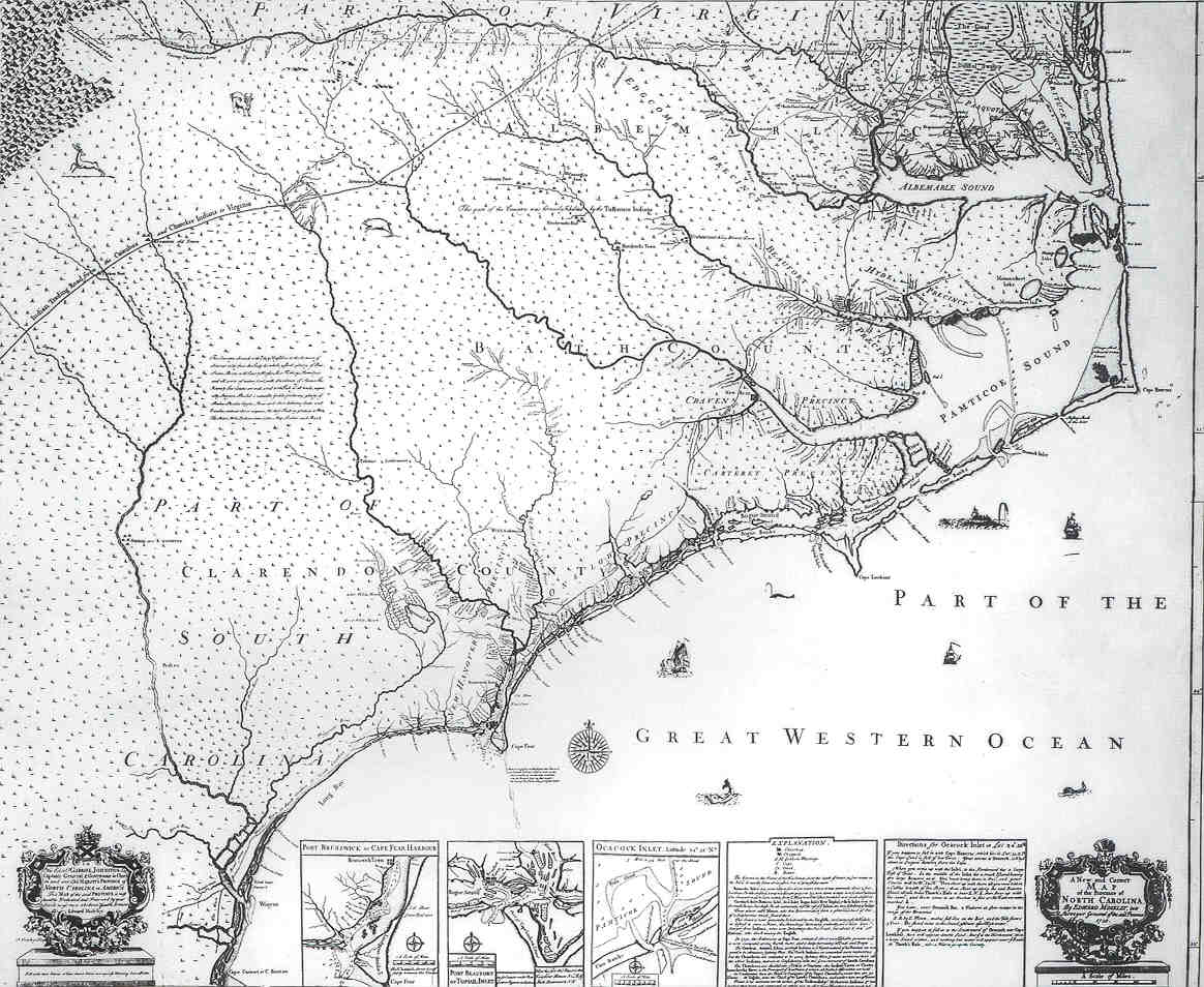
Figure 4
Perhaps because of the problems associated with settling the colony, North Carolina maps were limited both in the number created and in the quantities printed, and continued to be so until after the Revolutionary War. The first map to be solely devoted to and titled “North Carolina” and to illustrate the colony with any degree of accuracy was A New and Correct Map of the Province of North Carolina By Edward Moseley, late Surveyor General of the said Province 1733 engraved by John Cowley (Fig. 4).[8] It provided the most up-to-date geographical representation available from the 1730s until 1770 when John Abraham Collet’s A Compleat MAP of NORTH-CAROLINA from an actual Survey was issued. The only specifically North Carolina maps to predate the Moseley map were the 1585 maps drawn by John White.
William Cumming wrote in The Southeast in Early Maps, “Moseley’s [published] map is one of the most important type maps in the history of North Carolina cartography.”[9] Only three copies of the published map are known to exist. They are located at Eton College in England, the National Archives in Kew, England, and at East Carolina University in Greenville, North Carolina.
The published Moseley map is dated 1733 in the cartouche but was probably not issued until late 1736 or early 1737. The date 1733 most likely honors Gabriel Johnston’s appointment as governor of North Carolina that year. The published Moseley map is dedicated to Johnston. An alternative explanation for the 1733 date is that it was the year Edward Moseley completed the survey from which the published map was copied. It was not unprecedented for maps to be dated differently from the actual printing date.[10]
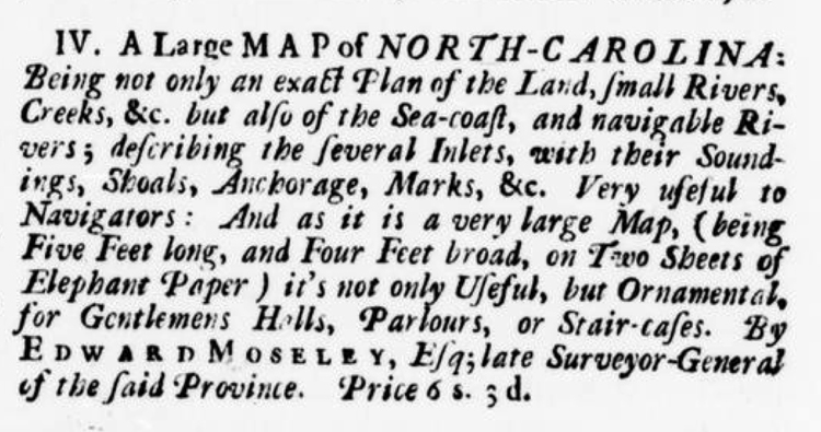
Figure 5
The Moseley map was undoubtedly highly anticipated. In May of 1735, a year and a half before it became available, Charleston, South Carolina printer Lewis Timothy advertised, “New and correct Maps of NORTH-CAROLINA by Edward Mosely [sic], dedicated to His Excellency the present Governor of the said Province, to be sold by the Printer hereof.”[11] Two years later, the map was offered for sale in the Virginia Gazette, described as “very large Map, (being Five Feet long, and Four Feet broad, on Two Sheets of Elephant Paper) it’s not only Useful, but Ornamental, for Gentlemens Halls, Parlours, or Stair-cases” (Fig. 5).[12]
Both the published Moseley map and the manuscript map (Fig. 1) were drawn in the shop of “J. Cowley” of London after a survey by Edward Moseley. To complete the commission for the published map, Cowley (or one of his workers) drew an image and engraved copperplates from which the maps were printed. Completely independent of the published Moseley map commission, someone appears to have hired Cowley to draw a similar map from the same survey by Moseley. The result is the manuscript map. Probably because Cowley had Moseley’s survey of North Carolina in his shop for the published map commission, the manuscript map was drawn from those same surveys. The manuscript map’s cartouche explicitly states that it was “drawn from the Original of Col. Mosely’s [sic] Survey,” not from the published Moseley map.
Hereafter, the manuscript map (Fig. 1) will be referred to as “the Moseley-Cowley manuscript map” or simply “the manuscript map.” The printed map (Fig. 4) will be referred to as “the published Moseley map”—to reflect the title used by scholars for years—or the “published map.”
John Cowley (w.c.1730-c.1750) was an appropriate choice to produce the maps of North Carolina. He was named royal cartographer to King George II and also taught mathematics at the Royal Military Academy at Woolwich. Further, he was a fellow of the Royal Society and wrote extensively on geographical and mathematical themes.[13]
Edward Moseley
The geography depicted on both the manuscript and published Moseley maps was surveyed during Edward Moseley’s tenure as surveyor general of the province. Variously described as “a cheat of the first magnitude” and one of North Carolina’s greatest patriots, Edward Moseley came to North Carolina from England.[14] In 1705 he was listed in the church records of New Bern, North Carolina, and by 1710 he was elected to the proprietary council of the province (the lower legislative body).[15] He practiced law, was an accomplished surveyor, and was a very successful businessman. His personal library was probably the largest in North Carolina during his lifetime. Where he was educated is unknown.[16]
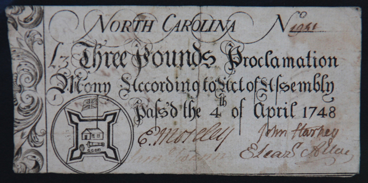
Figure 6
During his time in North Carolina, Moseley held numerous titles of importance: justice of the peace, chief baron of the exchequer, judge of the admiralty, public treasurer, surveyor general, speaker of the assembly, chief justice, and acting governor during Governor Burrington’s absence. Moseley’s signature appears on many provincial documents and can be found on much of the colonial currency of North Carolina (Fig. 6).[17]
Moseley participated in the three major colonial North Carolina surveys: those determining the border between North Carolina and Virginia (1728) (Fig. 7), the border between North Carolina and South Carolina (1735) (Fig. 8), and the line delineating Lord Granville’s lands (1744).[18] William Byrd II of Virginia, who accompanied Moseley on the North Carolina–Virginia border survey, wrote an account of the expedition titled A History of the Dividing Line Betwixt Virginia and North Carolina, in which he allegorically named all the members of the survey teams. Byrd described Moseley as “Plausible,” one of the more complimentary names given to any of the North Carolina members.[19]
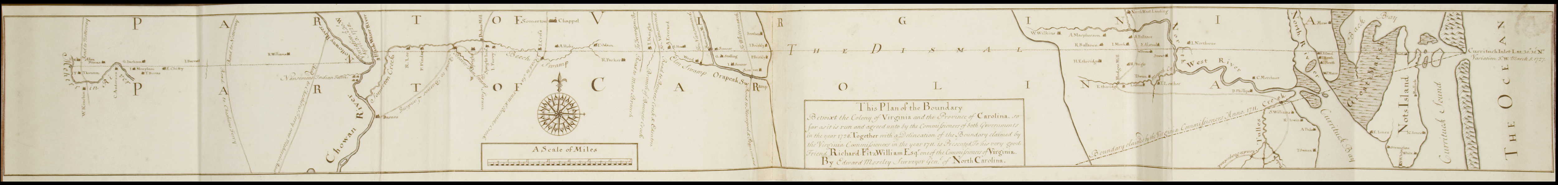 Figure 7 |
 Figure 8 |
Edward Moseley died in North Carolina in July 1749. His will, dated 20 March 1745, listed twelve plantations totaling well over 30,000 acres, and several other plantations had already been given to his children. Eighty-eight slaves were listed by name; three were freed, “having behaved very well.” He had six sons and one daughter by two wives. A codicil was added to the will in June 1748, after the unexpected birth of his last son, with the provision that “if I have any more children” they are to share in the lands. Edward Moseley left over 200 books on law to one son and another 150 books to family members. The late-nineteenth-century North Carolina historian George Davis wrote: “Of all the men who watched and guarded the tottering footsteps of our infant State, there was not one who, in intellectual ability, in solid and polite learning, in scholarly cultivation and refinement, in courage and endurance, in high Christian morality, in generous consideration for the welfare of others, in all the true merit… which makes a man among men, could equal Edward Moseley.”[20] The location of his grave is unknown.[21]
Earliest Depiction of the Boundary Line Between North Carolina & South Carolina
The most historically significant difference between the published Moseley map and the Moseley-Cowley manuscript map is the addition of the boundary line between the colonies of North Carolina and South Carolina on the latter. The province of Carolina was established in 1663 when King Charles II granted land to eight “Lords Proprietors” in recognition of their efforts in restoring the king to power. By 1712, Carolina was frequently being referred to as either North Carolina or South Carolina, and by 1729 they had become two separate royal colonies with King George II appointing governors to each. That same year, seven of the eight North Carolina proprietors sold their interest back to the Crown.[22] The remaining proprietor, John Carteret, Earl Granville (Lord Granville), retained his interest in the colony until the American Revolution. Frequent conflicts arose between the two colonies concerning the location of the boundary and which colony was responsible for security, granting land patents, and collecting taxes in the disputed region.[23] The manuscript map was the first to present the boundary line between North and South Carolina.[24]
In December 1730 King George II instructed North Carolina Governor George Burrington to “…transmit unto Us, and Our Commissioners for Trade and Plantations by the first Opportunity, a Map, with the exact Description of the whole Province under Your Government, with the Several Plantations upon it, and of the Fortifications, as also, of the bordering Indians Settlements.”[25] The king further instructed Burrington:
…that a Line Shall be run (by Commissioners Appointed by each Province) beginning at the Sea 30 Miles distant from the Mouth Cape Fear River, on the South West thereof, keeping the Same Distance from the Said River, as the Course thereof runs, to the main Source or Head thereof, And from thence the Said Boundary Line Shall be continued due West, as far as the South Seas; But if Waggamaw River, lies within 30 miles of Cape Fear River, then that River to be the Boundary from the Sea, to the Head thereof, and from thence to keep the Distance of 30 Miles parallel from Cape Fear River to the Head thereof; and from thence a due West Course, to the South Seas.[26]
Edward Moseley wrote the Duke of Newcastle in 1731: “I am preparing a large Map of this Province for his Majesty’s view, drawn from several Observations I collected when I was surveyor general of this Province and many helps I have received from several Gentlemen of this and the neighboring Governments.”[27] Whether Moseley actually prepared a map or simply delivered numerous surveys to be assembled is unknown.
In 1735 the governors of North and South Carolina each appointed commissioners to determine the boundary. Governor Burrington appointed five members from North Carolina, including Edward Moseley. On April 23 the commissioners met and agreed on where the boundary line should be, establishing that it should begin thirty miles from the west side of the mouth of the Cape Fear River and run northwest to a latitude of thirty-five degrees.[28]
The Board of Trade in London, unaware that the North and South Carolina commissioners had reached an agreement on the location of the boundary, also deliberated on the subject. The Board of Trade consisted of eight members appointed by the Crown tasked with promoting trade in the American plantations and elsewhere, including consideration of petitions for land grants. Their discussions about the boundary line suggest that the members of the Board of Trade were unaware of the locations of the rivers, in what direction they went, or how far they flowed.[29] Although Governor Gabriel Johnston informed the Board of Trade on May 25, 1735 that the commissioners had reached agreement, he failed to provide any details. They responded to Johnston, requesting a full description and draft map of the agreed-upon line.[30]
On September 10, 1735, the Board of Trade ordered “that a letter be wrote to Mr. Broughton Lt Governor of South Carolina for a Draught of the Boundary Line between the Province and North Carolina signed by the Commissioners who laid it out.”[31] In November 1736, they again wrote to Governor Johnston, noting:
In our letter to you of the 12th [sic] Sept 1735 We desired you would send us a full description of the Boundary Line between South Carolina and your Province and a draught thereof signed by the Commissioners or an authentic copy thereof under the seal but as we have not yet received it we must desire you will not fail sending the same by the first opportunity and that for the future you will be more punctual in sending to us such papers as we particularly write to you for.[32]
A copy of the boundary agreement of the commissioners seems not to have arrived in London until sometime in the second half of 1737.[33]
After the commissioners reached the 1735 agreement, the physical survey work began. Edward Moseley was one of the surveyors. The survey team determined the starting point at the sea to be the mouth of the Little River. In a letter to the Board of Trade dated October 6, 1737, North Carolina Governor Johnston reported that, “I have at last gott [sic] from the Commissioners an account of there [sic] Charges in running the Boundary Line with a Draft of so much of it as is already done which I send to you for their Lordships use by this Conveyance.”[34] The Board of Trade probably received the survey in late 1737 or early 1738.[35] Only sixty-two miles were surveyed in the initial attempt because the surveyors were not being paid and, as the records show, they ran out of rum. No other map is known to have attempted to delineate the boundary between the two colonies until John Collet published his map in May of 1770.
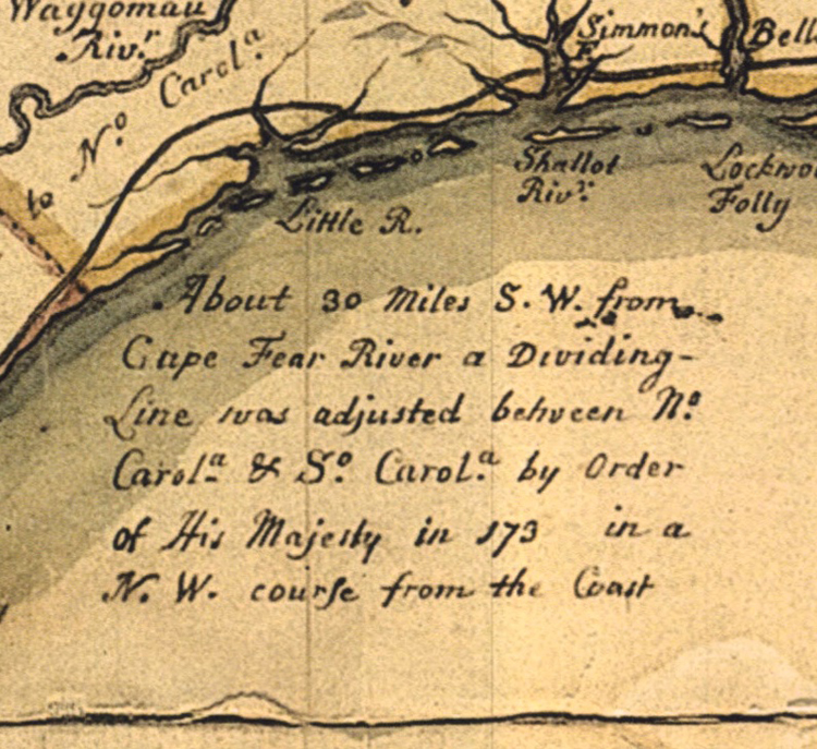
Figure 9
John Cowley delineated the boundary line on the manuscript map pursuant to the written agreement of the commissioners only as far as the Pee Dee River. Cowley began the line at the sea by measuring thirty miles southwest in a straight line from the Cape Fear River (by scale, three inches on the map) to the coast (the actual survey placed the starting line eight miles east at the mouth of the Little River). From that point, the boundary line heads northwest, stopping at the Pee Dee River. At the location on the coast where the boundary line begins a notation on the manuscript map reads: “About 30 miles S.W. from the Cape Fear River a Dividing Line was adjusted between No. Carolina & So. Carolina by order of His Majesty in 173_ [year blank] in a N.W. course from the coast” (Fig. 9). Cowley may have stopped the line at the Pee Dee River since it was difficult to determine where the line was to continue from that point based on the commissioners’ instructions.
The boundary line dispute between North and South Carolina continued until well after the Revolutionary War. Today, the boundary line between North and South Carolina generally follows the original commissioners’ agreement. To date, the depiction of the boundary line on the manuscript map is the earliest known, adding to the significance of the map’s survival.
Henry McCulloh and Arthur Dobbs: Early Land Speculators in the North Carolina Piedmont
McCulloh and Associates, an association of North Carolina landowners and speculators active during the second and third quarters of the eighteenth century, is frequently mentioned in the colonial records of North Carolina. The group included primarily Henry McCulloh and Arthur Dobbs, and later, several of their relatives and friends. The importance of this group of men to the history and development of colonial North Carolina cannot be overstated. McCulloh and Dobbs first appear in the colonial records of North Carolina in 1735, and they permeate the politics, economy, and development of North Carolina for the next thirty years.[36]
Their involvement in the region’s development does not end until after the Revolutionary War. The population of North Carolina grew from 30,000 in 1730 to well over 200,000 by 1770, and many of those new settlers bought land from McCulloh and Associates.[37]
Although Henry McCulloh appears to have been of Irish ancestry, he was born in Scotland around 1700.[38] Frequently referenced in North Carolina’s colonial records as a London merchant, McCulloh had amassed a modest fortune from the mercantile business by the end of the 1730s. With the exception of the Lords Proprietors, he was the largest landholder in the history of North Carolina. On May 16, 1739, he was appointed “Commissioner for Supervising, Inspecting, and Controlling our Revenues and Grants of Land in South and North Carolina.” He arrived in Charleston in early 1741 and soon established a plantation on the Northeast Cape Fear River.[39] While in North Carolina, McCulloh seems to have spent most of his time upsetting the locals and developing his lands. Despite accolades lauded on McCulloh during his lifetime, history and time have not been kind to him. One historian, Charles G. Sellers, Jr., said that people like Henry McCulloh “…explain in part why certain North Carolinians were willing to set their feet on the road that led to revolution in 1776.”[40]
Arthur Dobbs was born in Scotland in 1689 and moved to the ancestral home of the Dobbs family in Ireland a short time later. While in Ireland he was sheriff (1720), surveyor general (1730), a member of Parliament (1727-1730), engineer in chief (1733), and builder of the Castle Dobbs that exists today. As early as 1729, Dobbs was proposing various schemes to the British government concerning the American colonies. As one of McCulloh’s primary associates, Dobbs acquired his first piece of land in North Carolina, along with McCulloh, in 1735 on the Black River (part of a 60,000-acre grant). In January of 1753, Dobbs was commissioned as governor of North Carolina. He arrived in the colony in late 1754, in time to prepare its population for the French and Indian War.[41] Although he has been credited with fostering economic and demographic growth, he also fostered discontent and rebelliousness among the colonists.[42]
Henry McCulloh was instrumental in getting Gabriel Johnston, a political publicist from Scotland who had moved to London, appointed as governor of North Carolina in 1733. McCulloh loaned the new governor the money to pay for his commission and “freighting a ship to carry him and retinue to America, buying plate and furniture for his house, and providing him with credit to supply his immediate needs.”[43] McCulloh also acted as Johnston’s agent in London for official actions (and they were possibly related).[44]
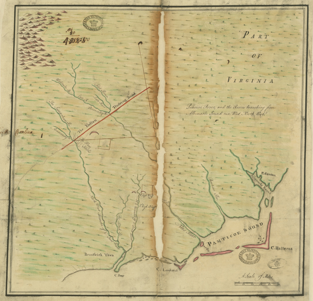
Figure 10
Governor Johnston did not arrive in North Carolina until late 1734. The new governor informed the council in North Carolina on November 29, 1735, that he had received a letter from Henry McCulloh and Arthur Dobbs applying for a grant of 60,000 acres on the Black River in order to settle “several poor Protestant Familys with design of Raising Flax and Hemp (a second parcel of 72,000 acres was later added to the request).”[45] The governor declared his intention of granting their request and the council unanimously approved. The Board of Trade in London, on February 12, 1736, ordered McCulloh “to lay before the Board as good a Draft of the two Tracts he desires as he can possibly get.”[46] The Board of Trade minutes from February 17 document that McCulloh presented “his Draught of the land he petitions for.” The “Draught,” now in the collections of the National Archives at Kew, was a crude and inaccurate manuscript map of a portion of North Carolina showing these two parcels of land (Fig. 10).[47] It appears to have been drawn in John Cowley’s shop from Moseley’s survey, as evidenced by the crescent-shaped mountain range in the upper left corner similar to the rendering on Moseley’s published map (Fig. 4). The king approved the request for the 60,000 acres and an additional 72,000 acres on the northeast branch of the Cape Fear River on April 29, 1736, with the understanding that no quit rents would be payable by McCulloh and Dobbs for ten years while they sought to attract settlers to the land.[48]
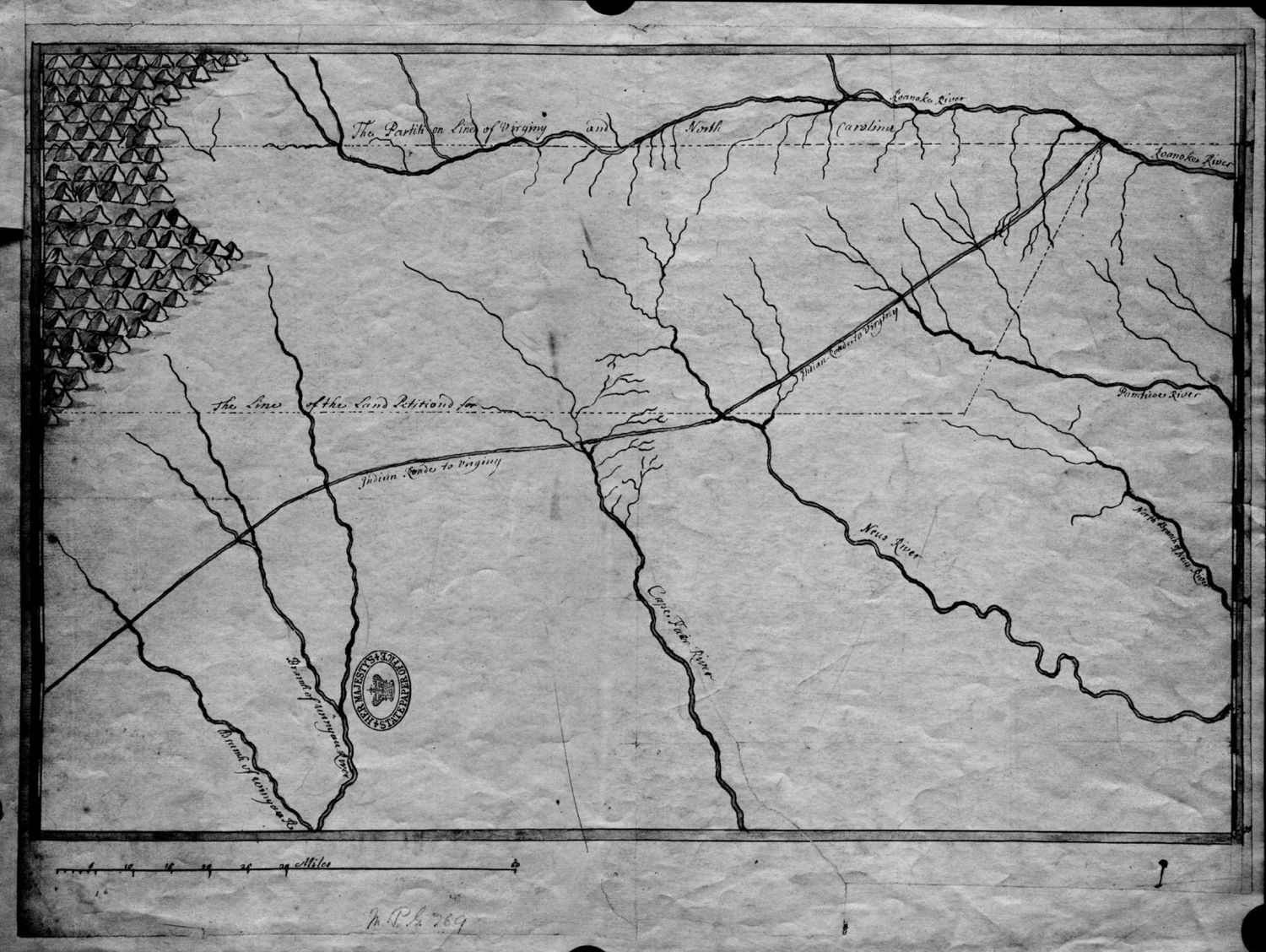
Figure 11
At the same time that McCulloh and Dobbs were submitting their request, former North Carolina Governor George Burrington and Samuel Jenner were also requesting large tracts of land in North Carolina in order to establish a settlement for 6,000 Swiss immigrants.[49] The land they sought was north of the land McCulloh and Dobbs were requesting and a manuscript map of the general area was provided to the Board of Trade (Fig. 11).[50] The Burrington/Jenner map is not a crude drawing and instead appears to be a tracing taken directly from the Moseley-Cowley manuscript map. Like the McCulloh manuscript map (Fig. 10), the Burrington/Jenner map was also likely drawn in Cowley’s shop (note the similar crescent-shaped mountain range in the upper left corner). Five of the seven rivers shown are mislabeled, however, possibly because neither the manuscript map nor the published Moseley map was yet completed. The Burrington/Jenner “draught” is also in the National Archives in Kew.
James Huey and Murray Crymble, two of McCulloh’s associates, were acting in trust for McCulloh when they requested and were granted 1.2 million acres of land in North Carolina, reporting that the land was to be for 6,000 settlers—just as Burrington/Jenner had cited in their petition.[51] They received this grant on May 7, 1736, eight days after McCulloh and Dobbs were granted the two parcels totaling 132,000 acres.[52] No further requests seem to have been made by the Burrington/Jenner group and the last mention in the Board of Trade records of this transaction is in late 1736. Their scheme appears to have died or was merged with the McCulloh and Associates transaction.
At the September 15, 1736 meeting of the Board of Trade in London, James Huey, on behalf of McCulloh and Associates, presented a map of North Carolina to support their petition for the 1.2 million acres.[53] This is a crucial detail for two reasons:
-
It establishes that the published Moseley map was not yet printed by September 1736. If the published Moseley map were available, the associates would not have had a need to present their own map to the Board of Trade in support of their petition. The published Moseley map was an official map that the board would have possessed well before any private citizens—and no other published map of North Carolina existed in 1736 that depicted the land in question.[54] The published Moseley map was probably not printed until several months later. Assuming that this timeline is accurate, the Moseley-Cowley manuscript map is predated only by the two 1585 manuscript maps drawn by John White.
-
Because the published Moseley map was not yet printed and no other map of North Carolina existed at the time, the map that the McCulloh and Associates submitted to the Board of Trade may have been the Moseley-Crowley manuscript map.[55]
Close examination of the manuscript map reveals several important characteristics that point to Henry McCulloh and Arthur Dobbs as the men most likely to have commissioned it, and to how they used it to support their request for land from the Crown. A detailed comparison of the manuscript map with the published map is presented as Appendix A. Three major differences support the argument that the manuscript map was indeed used by McCulloh and Associates to petition for their 1.2-million-acre land grant:
-
Unlike the published map, the manuscript map has multi-colored coastlines, meadows, mountains, borders, and a compass rose. The decorative coloring and additional details suggest the manuscript map was used to impress the Board of Trade and the king that their request would benefit the Crown.
-
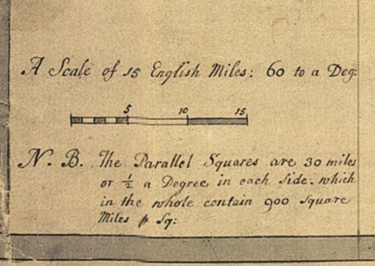
A note not seen on the published map was added to the manuscript map in the lower-left corner below the scale: “N.B. The Parallel Squares are 30 miles or ½ a Degree in each Side, which in the whole contain 900 square miles p Sq:” (Fig. 12). Period maps seldom, if ever, include square miles; however, the addition of the note makes the manuscript map ideal for identifying large land tracts. The note also helps explain the presence of the vertical lines on the manuscript map: the vertical lines shown on the face of the manuscript map are not longitude lines, but provide a way to determine the area of square miles.
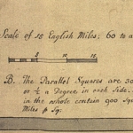
Figure 12
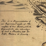
Figure 13
-
Most importantly, a narrative was added at the head of the Pee Dee River on the manuscript map that does not appear on the published map: “This is a Representation of an Improvement made at the conflux of two Rivers, which Demonstrates the advantages of Such a Situation, both for Profit, Pleasure & Security” (Fig. 13). This narrative dramatically highlighted the benefits to the king for McCulloh and Associates to populate the western lands they were requesting at the heads of the Pee Dee, Neuse, and Cape Fear rivers. Populating this land would have been invaluable to the king to protect his interests in coastal Carolina from encroachment by the Catholic French and their Native American allies on the frontier.
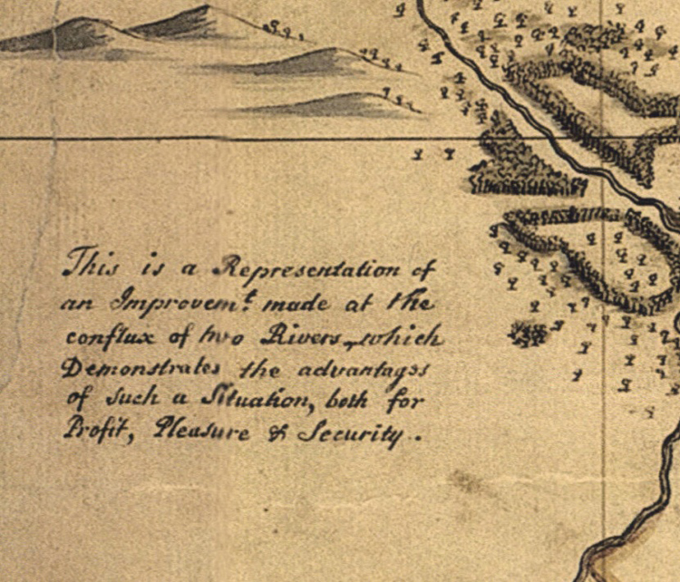
Thus, a strong argument can be made that McCulloh and Associates presented the Moseley-Cowley manuscript map to the Board of Trade on 15 September 1736.[56] The map speaks directly to the importance of establishing settlements on the colonial frontier for reasons of “Profit, Pleasure and Security.”
On May 19, 1737, His Majesty the King approved their petition, granting McCulloh and Associates “one million two hundred thousand Acres of Land to be surveyed in twelve different parcels of one hundred thousand Acres each.”[57] McCulloh and Associates now controlled nearly eight percent of all the land shown on the Moseley maps—the then-known parts of North Carolina—and opened new lands for settlement in the Piedmont.
Governor Johnston received notification of the grant of 1.2 million acres awarded to McCulloh and Associates by the fall of 1737.[58] Substantial fees were to be earned by surveying this large tract of land into “twelve different parcels of one hundred thousand Acres each,” as specified in the King’s decree. Since the surveyor general of North Carolina had died the year before, Governor Johnston appointed Mathew Rowan to the post.[59] In return, Rowan agreed to pay Samuel Woodard, a close associate of the governor, half of the fees and salary payable to the surveyor general for surveying the 1.2 million acres.[60] On March 4, 1738, just four days after the agreement between Rowan and Woodard was signed, Rowan and his party set out to survey the lands, taking seventy-eight days to complete the task.[61]
Surveyor General Mathew Rowan had no guidance from Henry McCulloh or any of his associates as to where the lands to be surveyed were located, only a copy of the written agreement from London. Following direction from Governor Johnston, Mathew Rowan surveyed nearly all the lands in the far west of the state, near the head of the Pee Dee River, but only a small portion at the heads of the Neuse and Cape Fear Rivers—land that would have been more valuable as it was farther east and closer to existing settlements. As a result, the relationship between Governor Johnston and Henry McCulloh deteriorated, and a legal battle ensued over where the land should be and how it should be surveyed.[62]
It was not until eight years later, on March 3, 1746, that the case between McCulloh and Governor Johnston was settled. McCulloh seems to have won. The payment of quit rents was deferred until ten years after the land was settled and Governor Johnston had to pay the cost of the initial survey.[63]
Johnston continued to serve as the governor of North Carolina until his death in 1752. He was buried at the plantation he inherited from his wife, Eden House, near Edenton. His tenure as governor of the colony spanned eighteen years, longer than any other governor in North Carolina’s history.[64]
Arthur Dobbs was appointed Governor in 1753 after Johnston’s death. Dobbs died in office on 27 March 1765 in North Carolina and was buried at St. Phillips Church in Brunswick, North Carolina.[65] In addition to his achievements as royal governor, surveyor, and successful land speculator, Dobbs may also be responsible for bringing to North Carolina’s shores the only published Moseley map known to survive in America. Ralph Scott, professor and curator of printed books and maps at East Carolina University, believes that Dobbs purchased the university’s copy in England and brought it with him when he traveled to North Carolina to become governor in 1754 (a timeline of the Moseley maps’ histories and related individuals is presented in Appendix B).[66]
Henry McCulloh’s influence grew in North Carolina and he became an acknowledged expert on colonial affairs. He developed his personal plantation, Sarecta, on the northeast branch of the Cape Fear River.[67] McCulloh returned to England in 1747 and never returned to North Carolina; however, he continued to be very active in colonial affairs and died in England in 1779.[68]
Through business, political, and personal relationships, Arthur Dobbs and Henry McCulloh greatly influenced the politics of North Carolina for thirty-two of the forty-three years of North Carolina’s royal governors. McCulloh and Associates controlled most of the private lands available for settlement in the colony until the Revolutionary War. The efforts of McCulloh and Dobbs to promote their public and private interests encouraged substantial immigration to the colony. From 1736 to Henry McCulloh’s death in 1779, North Carolina’s population burgeoned with English, Scots-Irish, and German settlers moving into the Piedmont to occupy the twelve tracts of land brokered by McCulloh and Associates.[69]
The Manuscript Map and the Portrait of Arthur Dobbs
In late 1752, while in Bath, England, and awaiting his commission as governor of North Carolina, Arthur Dobbs had his portrait painted by the fashionable English artist William Hoare.[70] Shortly after Hoare completed the painting, Dobbs commissioned James McArdell to make a mezzotint engraving of the portrait so that prints could be made for Dobbs to present to family, friends, and colleagues (Fig. 14).[71] The print depicts a learned-looking older gentleman. In the background a ship is sailing out to sea, and a globe with the arctic region exposed is featured. Dobbs holds in his right hand a compass and in his left hand a map that appears to be North Carolina and is in fact labeled “North Carolina.” Might the map he is holding be the manuscript map?
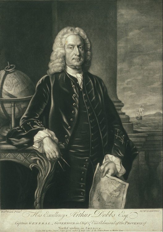 Figure 14 |
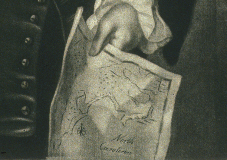 Figure 15 |
Dobbs’s biographer, Desmond Clarke, described the oil portrait saying, “The artist skillfully suggests the many activities of the sitter, who, compass in hand, studies a map of the Arctic regions [emphasis added].”[72] Clarke claimed to have viewed the painting, noting that it hung in the dining room at Castle Dobbs (Figs. 16 and 17).
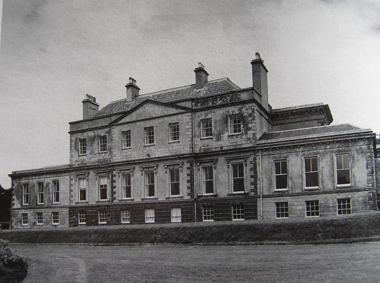 Figure 16 |
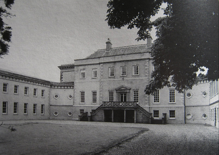 Figure 17 |
At the time that Dobbs’s portrait was painted and the mezzotint engraving prints were created, around 1752, there was only one published map of the colony that was titled North Carolina and that represented up-to-date geography based on actual surveys: Moseley’s A New and Correct Map of the Province of North Carolina in America. The map that Dobbs holds in his hand in the print is too small and does not resemble Moseley’s published map. However, it is the approximate size and shape of the manuscript map (Fig. 15). The compass rose on the map in the print is located in the same position as that on the manuscript map. There is no cartouche visible on the map that Dobbs is holding in the engraving; however, the area in lower right, where the cartouche appears on the manuscript, extends beyond the engraved image. Moreover, there are a number of features on the map that Dobbs is holding that resemble the geography of North Carolina: the coastline, the Virginia/Carolina border, the Indian Road, the Albemarle Sound, the Meherrin River, the Roanoke River, the Neuse River, the Cape Fear River, Cape Lookout, Cape Fear, and the Wagamau River. Given the similarities between the manuscript map and the one held by Arthur Dobbs in the print, it is possible that this was the map that Dobbs chose as the prop for his painted likeness.
In 1990, a Dobbs descendent bequeathed a nineteenth or early twentieth-century copy of Dobbs’s likeness to the North Carolina Museum of History in Raleigh, North Carolina (Fig. 18).[73] The Burgwin-Wright House Museum in Wilmington also has a painting of Dobbs, taken either after the original painting or the print, that they acquired earlier in the twentieth century (Fig. 19). Dobbs appears to be holding a map of North Carolina in both paintings.
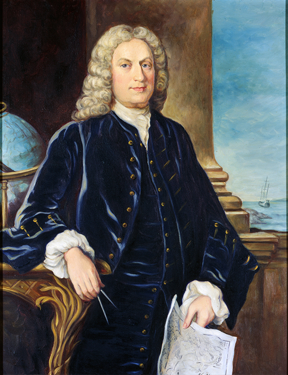 Figure 18 |
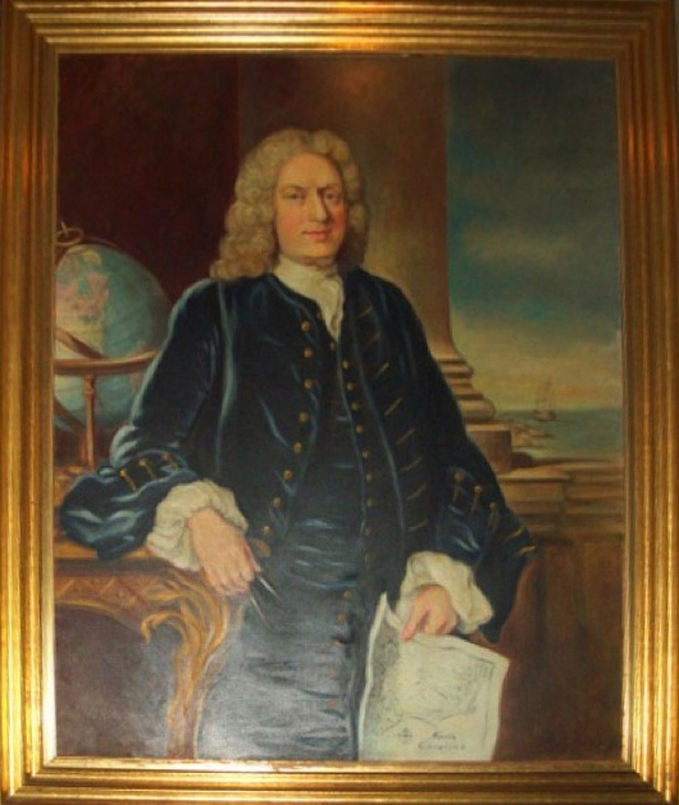 Figure 19 |
The most significant piece of evidence suggesting that Dobbs is the original owner of the Moseley-Cowley manuscript map is housed at the Public Record Office of Northern Ireland (PRONI). PRONI holds a substantial collection of Dobbs papers, including manuscript inventories of Arthur Dobbs’s libraries, both in Northern Ireland and North Carolina, apparently taken at the time of his death (Fig. 20). His library in Northern Ireland contained well over 1,000 volumes, including a number of atlases, maps, and well-known books such as Hakluyt’s The Principal Navigations (1598), Catesby’s Natural History of Carolina, Florida and the Bahama Islands (1731-1743), Keith’s The History of the British Plantations in America (1738), Oldmixon’s The British Empire in America (1708), and numerous others pertaining to the colonies and exploration. Listed on the second shelf of the catalog of his Northern Ireland library was the entry, “Carolina” (Figs. 21 and 22) The label on the reverse of the manuscript map, “2S, Col Mosley’s [sic] Map,” could indicate that the map was formerly housed on the second shelf of Arthur Dobbs’s library at Castle Dobbs (Fig. 3).
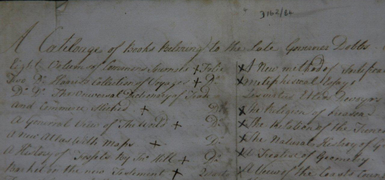 Figure 20 |
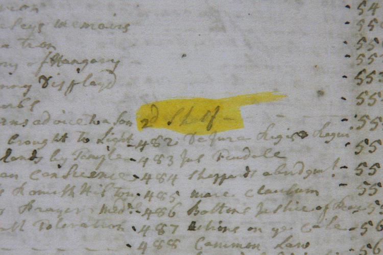 Figure 21 |
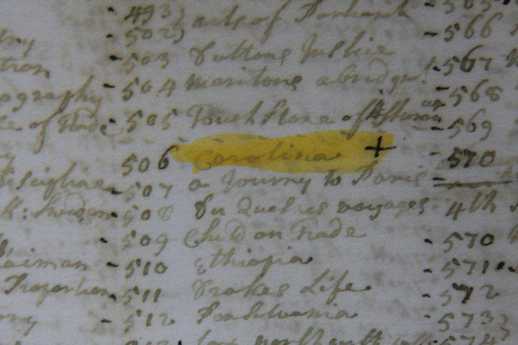 Figure 22 |
Conclusion
The Moseley-Cowley manuscript map of North Carolina is a rare surviving colonial document and a significant historical artifact. The map depicts the most up-to-date knowledge of the geography of North Carolina known at that time, including the first attempt to delineate the agreed-upon border between North and South Carolina, an important milestone in the evolution of North Carolina as a colony independent of its southern neighbor.
Documents suggest that Henry McCulloh and Arthur Dobbs commissioned John Cowley to draw this significant manuscript map taken from surveys by Edward Moseley, and presented it to the Board of Trade in 1736 to support a petition by McCulloh and Associates for 1.2 million acres of land. As a direct result of land grants awarded to McCulloh and Associates, the population of North Carolina grew from 30,000 in 1730 to well over 200,000 by 1770. North Carolina had become the third-most-populous state by 1790, when the first United States census was taken, surpassed only by Virginia and Pennsylvania. The manuscript map cartographically illuminates the people and processes that drove North Carolina’s population growth in the eighteenth century.
Mike McNamara is an independent scholar and collector who lives in Williamsburg, Virginia. He can be reached at [email protected].
Appendix A: Comparison of the Two Moseley Maps
-
The published Moseley map is 57.125 inches by 45.25 inches (2,585 square inches) and the Moseley-Cowley manuscript map is 27.75 inches by 22.25 inches (617 square inches). The published map is more than four times larger than the manuscript map.
-
The published map has two cartouches. One dedicates the map to the new governor of North Carolina, Gabriel Johnston, and the second is simply the title. The manuscript map has one title cartouche. Both maps are titled “A New and Correct Map of the Province of North Carolina.”
-
The published map has no color, as was common for maps used for official purposes. The manuscript map has multi-colored coastlines, meadows, mountains, borders, and a compass rose, suggesting the map was used for promotional purposes or for decoration.
-
The latitude lines shown on the manuscript map are shown on the face of the map but are only shown in the border on the published map. Vertical lines are shown on the face of the manuscript map but they are not longitude lines; they may have been included to allow for determining the area of square miles.
-
The manuscript map shows the boundary between North and South Carolina, the first time the agreed to boundary appears on a map. The boundary line does not appear on the published map.
-
Precinct (county) boundaries were added and colored on the manuscript map and do not appear on the published map.
-
A note not seen on the published map was added to the manuscript map in the lower-left corner below the scale: “N.B. The Parallel Squares are 30 miles or ½ a Degree in each Side which in the whole contain 900 square miles p Sq:” (Fig. A1). Period maps seldom, if ever, deal with square miles; however the note helps explain the presence of the vertical lines on the manuscript map.
-
A curious narrative is added at the head of the Pee Dee River on the manuscript map that does not appear on the published map: “This is a Representation of an Improvement made at the conflux of two Rivers, which Demonstrates the advantages of Such a Situation, both for Profit, Pleasure and Security” (Fig. A2). McCulloh and Associates was seeking land in the 1736 at the “conflux” (head) of the Pee Dee, Neuse, and Cape Fear rivers.
-
Numerous plantation owner names are noted on the published map but not on manuscript map, except for Stag Park, Governor Burrington’s plantation on the Northeast Branch of the Cape Fear River. Stag Park was also identified on earlier maps of the area before Burrington’s time.
-
At the Nottoway River the two maps diverge as to whether the Virginia–North Carolina boundary line is to jog north or south.
-
Most references to “Ind. T.” (Indian tribe) have been deleted on the manuscript map but appear on the published map.
-
The far western town of “Pedees” has more houses on the manuscript map than on the published map.
-
The manuscript map has two unnamed branching rivers added after completion of the map that do not appear on the published map. One river is added to the “Great Pedee” and one to the “Little Pedee.” These may have been added later in 1737 once the actual boundary survey was received in London showing these additional rivers.
-
“Neus or New Bern River” has been added to the manuscript map to what is also identified as “Conneghta Creek” on both maps. The Neuse River is actually further west but is not labeled on the published map. The confusion may come from the 1736 land survey of Henry McCulloh’s and Arthur Dobbs’s first land grants, which incorrectly identifies the proper Neuse River as the Acconechy River. It may also come from the Burrington/Jenner 1737 “draught” in which the Conneghta Creek is labeled as the “North Branch of Neus River.”[74]
-
The northwest branch of the Cape Fear River is labeled on the manuscript map but not on the published map.
-
A note regarding the location of Cape Henry (in Virginia) is added to the northeast portion of the manuscript map but does not appear on the published map.
-
Western villages and towns have more structures shown on the manuscript map than on the published map.
-
The word “Town” has been eliminated from names of Bath, Brunswick, and Beaufort on the manuscript map but appear on the published map.
-
The label “Pamtico River” [sic] has been added to the upper reaches of the river on the manuscript map but does not appear on the published map.
Appendix B: Moseley Maps Timeline
|
1730 |
December |
George Burrington is appointed governor of North Carolina by King George II and instructed to prepare a map of the colony |
|
1731 |
May |
Edward Moseley sends a letter to Duke of Newcastle stating that he is preparing a “large Map of the North Carolina” |
|
1733 |
March |
Gabriel Johnston is appointed governor of North Carolina; the published Moseley map is dedicated to Johnston and also dated 1733 |
|
1734 |
November |
Governor Johnston arrives in North Carolina |
|
1735 |
April |
Commissioners from North and South Carolina agree upon a boundary line between the two colonies |
|
|
June |
The Board of Trade in London discusses where the boundary should be—apparently without an accurate map |
|
|
September |
The Board of Trade writes Governor Johnston requesting a copy of the boundary agreement |
|
|
November |
Governor Johnston receives a letter from Henry McCulloh and Arthur Dobbs requesting land grants for 60,000 acres in North Carolina |
|
|
December |
The North and South Carolina boundary survey probably completed |
|
1736 |
February |
McCulloh & Associates and George Burrington/Samuel Jenner present “draughts” to the Board of Trade showing the locations of the North Carolina lands they each seek |
|
|
April |
McCulloh and Associates is granted 132,000 acres of land |
|
|
May |
McCulloh and Associates (Huey and Crymble) request 1.2 million acres of land |
|
|
September |
McCulloh and Associates (Huey) presents a “Map of North Carolina” at the Board of Trade to support its petition for the 1.2 million acres (possibly the Moseley-Crowley manuscript map) |
|
|
November |
The Board of Trade writes Governor Johnston once again asking for copy of North Carolina–South Carolina boundary agreement |
|
|
Nov/Dec |
Published Moseley map is probably printed, prior to receipt of the boundary agreement in London |
|
1737 |
May |
McCulloh and Associates is granted 1.2 million acres of land |
|
|
September |
Published Moseley map advertised for sale in the Virginia Gazette |
|
|
October |
Governor Johnston writes the Board of Trade that he has received the boundary survey and charges for running the line |
|
|
Oct/Nov |
Governor Johnston receives word of McCulloh’s 1.2-million-acre land grant |
|
1738 |
March |
Mathew Rowan, North Carolina’s surveyor general, sends out a survey team to identify McCulloh’s 1.2 million acres |
|
1739 |
May |
The proprietors appoint Henry McCulloh as “Commissioner for Supervising, Inspecting, and Controlling our Revenues and Grants of Land in South and North Carolina” |
|
1741 |
|
McCulloh arrives in Charleston, soon to establish a plantation on the Northeast Cape Fear River. |
|
1746 |
March |
McCulloh’s suit over Rowan’s survey for the 1.2-million-acre land grant is settled |
|
1747 |
|
McCulloh returns to England |
|
1749 |
July |
Edward Moseley dies in North Carolina |
|
1752 |
July |
Governor Gabriel Johnston dies in Edenton |
|
|
December |
In England, William Hoare paints Arthur Dobbs portrait |
|
1753 |
January |
Arthur Dobbs officially commissioned as governor of North Carolina |
|
1754 |
October |
Governor Dobbs arrives in North Carolina |
|
1753 |
|
James McArdell makes a mezzotint engraving of Hoare’s painting of Arthur Dobbs |
|
1765 |
March |
Governor Dobbs dies in North Carolina |
|
1770 |
May |
John Abraham Collet map of North Carolina is published, replacing the printed Moseley map as the most up-to-date map of North Carolina |
|
1779 |
June |
Henry McCulloh dies in England |
[1] The manuscript map is also available for online viewing at the “North Carolina Maps” project (accessed 5 December 2011): http://dc.lib.unc.edu/cdm4/item_viewer.php?CISOROOT=/ncmaps&CISOPTR=1245&CISOBOX=1&REC=2.
[2] Margaret Pritchard, Colonial Williamsburg Foundation’s curator of prints, maps, and wallpaper, to the author.
[3] The map has been conserved by Pam Young, paper conservator at Colonial Williamsburg. The nineteenth-century linen lining was removed by peeling back the fabric in narrow strips. Discolored adhesive residue was removed by swabbing with a diluted enzyme solution and water. The map was bathed on a suction table, allowing discoloration, stains, and brittleness to be reduced without risk to the ink and watercolor paint design layers. Losses in the paper were filled with laid paper of similar weight, color, and texture, and the tears were mended on the verso with strips of Japanese paper adhered with wheat starch paste.
[4] William S. Powell, North Carolina Through Four Centuries (Chapel Hill: University of North Carolina Press, 1989), 105, 572.
[5] Warren M. Billings, John E. Selby, and Thad W. Tate, Colonial Virginia: A History (White Plains, NY: KTO Press, 1986), 252; Walter Edgar, South Carolina: A History (Columbia: University of South Carolina Press, 1998), 78.
[6] Powell, North Carolina Through Four Centuries, 80, 83-84.
[7] Willam S. Powell, ed., Dictionary of North Carolina Biography (Chapel Hill: University of North Carolina Press, 1991), vol. 4, 332-333.
[8] The published Moseley map measures 57” by 45.25” (more than four times the size of the manuscript map). The Printed Moseley Map is also available for online viewing at East Carolina University’s Joyner Library “Digital Collections” site (accessed 5 December 2011): http://digital.lib.ecu.edu/1028.
[9] William P. Cumming, The Southeast in Early Maps, 3rd ed. (Chapel Hill: University of North Carolina Press, 1998), 235.
[10] Another example of a map dated earlier than its initial printing is “A Map of the most INHABITED part of VIRGINIA containing the whole PROVINCE of MARYLAND with Part of PENNSYLVANIA, NEW JERSEY AND NORTH CAROLINA” by Joshua Fry and Peter Jefferson, dated 1751 in the cartouche but first printed about 1753 with subsequent printings in 1754, 1755, and 1768 before the title date was changed in 1775. Margaret Beck Pritchard and Henry G. Talliaferro, Degrees of Latitude: Mapping Colonial America (Williamsburg, VA: Colonial Williamsburg Foundation with Harry N. Abrams, NY), 154-159. See also MESDA’s online catalog (accessed 10 December 2011): http://mesda.org/collections/paper_sprite/mesda_a-map-of-the-most-inhabited-part-of-virginia….html.
[11] South-Carolina Gazette, Charleston, South Carolina, 3 May 1735, 4-1.
[12] Virginia Gazette, Williamsburg, Virginia, 9 September 1737.
[13] Josephine French, ed., Tooley’s Dictionary of Mapmakers, revised edition (Wiltshire, England: Map Collector Publications, 1999), 308.
[14] Moseley was born in 16 February 1682/83 in London, England. His father was John Moseley, a cloth-worker, draper, or merchant tailor that died sometime before 1690. Moseley’s education was completed at Christ’s Hospital, Newgate, London, in a division called The Royal Mathematical School that trained navigators to the navy and merchant marine. Moseley’s schooling in mathematics and navigation at Christ’s Hospital provided him with the skills required for his later land surveying in Carolina. Baylus C. Brooks, Aristocratic Pyrates of the Albemarle: A Family Memoir (published by the author, 2010), 6-10. Available online (accessed 4 June 2012): http://www.lulu.com/shop/bc-brooks/aristocratic-pyrates-of-the-albemarle/ebook/product-17570555.html.
[15] Powell, Dictionary of North Carolina Biography, vol. 4, 332.
[16] Ibid, 332-333.
[17] Ibid.
[18] Ibid.
[19] Louis B. Wright, ed., The Prose Works of William Byrd of Westover: Narratives of a Colonial Virginian (Cambridge, MA: Harvard University Press, 1966).
[20] George Davis, A Study in Colonial History (Wilmington, NC: Jackson & Bell Printers, 1880), 21. Available online (accessed 5 December 2011): http://books.google.com/books?id=z0wtAAAAYAAJ&vq=moseley&source=gbs_navlinks_s.
[21] J. Bryan Grimes, North Carolina Wills and Inventories (Raleigh, NC: NC Public Libraries, 1912), 313-320. Available online (accessed 5 December 2011): http://digital.lib.ecu.edu/historyfiction/search/results.aspx?t=moseley&id=grn&type=single.
[22] Powell, North Carolina Through Four Centuries, 53, 86.
[23] Ibid, 95.
[24] Henry Popple, an English cartographer, published in 1733 “A Map of the British Empire in America with the French and Spanish Settlements adjacent thereto.” The Popple map was printed in twenty sheets that, when assembled, formed a map that was 95” by 100” and included a “key” map, or index, of one sheet showing the assembled large map with numbered sheets. The Popple map shows the Waggamaw River (incorrectly) within thirty miles of the Cape Fear River and flowing in a northwest direction, a potential boundary line as directed in the instructions from the king to Governor Burrington. Popple’s key map, but not the large assembled map, has a dotted line as a boundary line between North and South Carolina along the Waggamaw River. This dotted line is not an accurate boundary, as the line was not agreed upon until 1735, two years after Popple’s map was produced. Also, the Waggamaw River, in reality, does not flow northwest, but east northeast and actually ends in a lake not more than thirty miles from the coast as shown on the two Moseley maps.
[25] Instructions to George Burrington Concerning the Government of North Carolina, from George II, King of Great Britain, 14 December 1730, The Colonial and State Records of North Carolina, vol. 3, p. 115. Available online (accessed 5 December 2011): http://docsouth.unc.edu/csr/index.html/document/csr03-0060.
[26] Ibid.
[27] Cumming, The Southeast in Early Maps, 236.
[28] Articles of agreement between North Carolina and South Carolina concerning the boundary North Carolina and South Carolina, 23 April 1735, The Colonial and State Records of North Carolina, vol. 5, p. 374-375. Available online (accessed 5 December 2011): http://docsouth.unc.edu/csr/index.html/document/csr05-0123. The full instructions were:
…agreed and Concluded on by and between the aforesaid Commissioners being as near as may be Agreeable to the sense of his Majestys Royal Instructions for settling the said Boundarys.
1st. That the Line to be run shall begin at the Sea thirty Miles distance from the West side of the Mouth of Cape Fear River.
2nd. That from thence a Line be run on a North West course to the Latitude of thirty five degrees No. and from thence due West to the South Seas.
3rd. That if the said North West course before it reaches to the Latitude of thirty five degrees shall fall within five Miles of Pedee River then a course shall be run parallel to that River at five Miles distance to the Latitude of thirty five degrees No. and from thence a due West course as before Provided that such parallel line do not approach nearer to Cape Fear River than thirty Miles. And in such case a North West course shall be continued from that place where it shall be found to approach within the said thirty Miles of Cape Fear River.
4th. That if the said West Line shall take in any part of the Nations of Indians called the Cherokees or Catalbas [sic], then such line shall be set off, so as to include the said Indians within the Government of South Carolina, until such line shall again come to the Latitude of thirty five degrees, and from thence a due West Line as before.
5th. That the above Articles be jointly and interchangeably executed to each Other by the respective Commissioners of both Provinces under their several hands and Seals
[29] Minutes of the Board of Trade of Great Britain, 6, 19, 13 26 June 1735, The Colonial and State Records of North Carolina, vol. 4, p. 27-29. Available online (accessed 5 December 2011): http://docsouth.unc.edu/csr/index.html/document/csr04-0016.
[30] Letter from the Board of Trade of Great Britain to Gabriel Johnston, 12 September 1735, The Colonial and State Records of North Carolina, vol. 4, p. 17. Available online (accessed 5 December 2011): http://docsouth.unc.edu/csr/index.html/document/csr04-0010. The complete request reads:
The Boundary Line between South Carolina and your Province we find has been adjusted by Commissioners on both sides and we shall always have a proper regard to so solemn a determination agreed to by persons properly empowered by each of the Provinces when you gave us this intelligence you ought to have sent us a full description of the said line and a Draught thereof signed by the Commissioners or an authentic copy thereof under the seal which we desire you will do as soon a conveniently you can.
[31] Minutes of the Board of Trade of Great Britain, 10 September 1735, The Colonial and State Records of North Carolina, vol. 4, p. 214. Available online (accessed 5 December 2011): http://docsouth.unc.edu/csr/index.html/document/csr04-0016.
[32] Letter from the Board of Trade of Great Britain to Gabriel Johnston, 11 November 1736, The Colonial and State Records of North Carolina, vol. 4, p. 201. Available online (accessed 5 December 2011): http://docsouth.unc.edu/csr/index.html/document/csr04-0066.
[33] Letter from Gabriel Johnston to the Board of Trade of Great Britain, 30 April 1737, The Colonial and State Records of North Carolina, vol. 4, pp. 249-251. Available online (accessed 5 December 2011): http://docsouth.unc.edu/csr/index.html/document/csr04-0088.
[34] Letter from Gabriel Johnston to Alured Popple, Board of Trade of Great Britain, 6 October 1737, The Colonial and State Records of North Carolina, vol. 4, p. 267. Available online (accessed 5 December 2011): http://docsouth.unc.edu/csr/index.html/document/csr04-0099.
[35] The survey document is held in the Public Record Office in England.
[36] Minutes of the North Carolina Governor’s Council, 29 November 1735, The Colonial and State Records of North Carolina, vol. 3, p. 72. Available online (accessed 6 December 2011): http://docsouth.unc.edu/csr/index.html/document/csr04-0043.
[37] Powell, North Carolina Through Four Centuries (Chapel Hill: University of North Carolina Press, 1989), 572.
[38] Some confusion exists in the Colonial Records of North Carolina as there were two men of similar names active at that time. Henry McCulloh (confusingly sometimes spelled “McCulloch”) and a Henry McCulloch were both involved in North Carolina and may have been cousins. McCulloch was briefly appointed secretary of North Carolina but was referred to as the “nagging place hunter” by Lord Halifax and described as an “insignificant civil servant.” Willam S. Powell, ed., Dictionary of North Carolina Biography, vol. 4, 133; John Cannon, “Henry McCullcoh and Henry McCulloh,” William and Mary Quarterly, 3rd series, vol. 15, no. 1 (1958): 71-73.
[39] Powell, ed., Dictionary of North Carolina Biography, vol. 4, 133; Charles G. Sellers, Jr., “Private Profits and British Colonial Policy: The Speculations of Henry McCulloh,” William and Mary Quarterly, 3rd series, vol. 8, no. 4 (October 1951): 543.
[40] Sellers, 535.
[41] Order of the Privy Council of Great Britain concerning the appointment of Arthur Dobbs as Governor of North Carolina, 25 January 1753, The Colonial and State Records of North Carolina, vol. 5, p. 16-17. Available online (accessed 6 December 2011): http://docsouth.unc.edu/csr/index.html/document/csr05-0004.; Powell, ed., Dictionary of North Carolina Biography, vol. 2, 85.
[42] Powell, ed., Dictionary of North Carolina Biography, vol. 2, 86.
[43] Sellers, 536.
[44] Ibid.
[45] Minutes of the North Carolina Governor’s Council, 29 November 1735, The Colonial and State Records of North Carolina, vol. 3, p. 72. Available online (accessed 6 December 2011): http://docsouth.unc.edu/csr/index.html/document/csr04-0043.
[46] Minutes of the Board of Trade of Great Britain, 12 February 1736, The Colonial and State Records of North Carolina, vol. 4, p. 12. Available online (accessed 6 December 2011): http://docsouth.unc.edu/csr/index.html/document/csr04-0072.
[47] Minutes of the Board of Trade of Great Britain, 17 February 1736, The Colonial and State Records of North Carolina, vol. 4, p. 14. Available online (accessed 6 December 2011): http://docsouth.unc.edu/csr/index.html/document/csr04-0072.
[48] Order of the Privy Council of Great Britain concerning a petition from Henry McCulloh concerning land grants in North Carolina, 29 April 1736, The Colonial and State Records of North Carolina, vol. 4, pp. 162-162. Available online (accessed 6 December 2011): http://docsouth.unc.edu/csr/index.html/document/csr04-0057.
[49] Minutes of the Board of Trade of Great Britain, 22 January 1736, The Colonial and State Records of North Carolina, vol. 4, pp. 209. Available online (accessed 6 December 2011): http://docsouth.unc.edu/csr/index.html/document/csr04-0072.
[50] Ibid, 29 January 1736, 209. Available online (accessed 6 December 2011): http://docsouth.unc.edu/csr/index.html/document/csr04-0072.
[51] Ibid, 5 May 1736, 212. Available online (accessed 6 December 2011): http://docsouth.unc.edu/csr/index.html/document/csr04-0072.
[52] A search of the Minutes of the Board of Trade for 1736-1737 did not reveal any North Carolina land granted to Huey and Crymble. Minutes of the Board of Trade of Great Britain, 1736-1737, The Colonial and State Records of North Carolina, vol. 4. Available online (accessed 6 December 2011): http://docsouth.unc.edu/csr/index.html/volumes/volume_04.
[53] Minutes of the Board of Trade of Great Britain, 15 September 1736, The Colonial and State Records of North Carolina, vol. 4, p. 213. Available online (accessed 6 December 2011): http://docsouth.unc.edu/csr/index.html/document/csr04-0072.
[54] One of the three known surviving copies of the published Moseley map was originally owned by the Board of Trade and is now deposited in the National Archives in Kew, England.
[55] The manuscript map was most likely completed at this time; however, as new information came to be known, such as the boundary line agreement and later the survey, it was added to the manuscript map.
[56] When shown the Moseley-Crowley manuscript map for the first time, Peter Barber, head of the map collections at the British library immediately commented that the map “would likely have been used in a presentation to the Board of Trade.” Conversation with the author, June 2009.
[57] Order of the Privy Council of Great Britain concerning Henry McCulloh’s land grants in North Carolina, 19 May 1737, The Colonial and State Records of North Carolina, vol. 4, pp. 252-253. Available online (accessed 6 December 2011): http://docsouth.unc.edu/csr/index.html/document/csr04-0091. The complete grant reads:
the humble Petition of Murray Crymble and James Huey of London Merchants in behalf of themselves and several others praying for a Grant of Lands upon the heads of the Pedee Cape Fear and Neus Rivers in North Carolina, and Proposing to make a Settlement theron of six thousand Swiss Palatines and other Foreign Protestants within the space of Ten years from the Date of their Grant, The Lords of the Committee have taken the said Petition into their consideration and have received the Opinion of the Lords Commissioners for Trade and Plantations thereupon and having been several times attended by the Petitioners do find that they are willing to undertake the Settlement up the following Conditions—Vis
That they be allowed one million two hundred thousand Acres of Land to be surveyed in twelve different parcels of one hundred thousand Acres each.
That these twelve parcels be laid out as contiguous as may be but none of them to be at any greater distance than ten miles from some other of them.
That these twelve parcels so surveyed be Granted by the Governour to the Petitioners and their Associates in such proportions as shall be required by them but no Grant to contain less than twelve thousand acres.
That the Petitioners and their associates do pay the usual Fees for surveying and passing the Grants of the said Tracts.
That all the Grants be made by the Governour immediately upon the return of the surveys to him and that they do bear equal date with each other.
That the commencement of the Quit Rent be computed from the expiration of Ten years from the date of such Grant which Quit Rent is to be four Shillings Proclamation Money for every hundred acres included in the said Grants.
That in case any Mines shall be found in the Land petitioned for one fifth part of all Gold and Silver Ore and one tenth part of the Ore of all other Mines and Minerals whatsoever be reserved to your Majesty.
[58] Sellers, 541.
[59] Minutes of the North Carolina Governor’s Council, 21 September 1736, The Colonial and State Records of North Carolina, vol. 4, p. 222. Available online (accessed 6 December 2011): http://docsouth.unc.edu/csr/index.html/document/csr04-0077.
[60] Petition from Henry McCulloh concerning land grants in North Carolina, 8 June 1749, The Colonial and State Records of North Carolina, vol. 4, p. 1079. Available online (accessed 6 December 2011): http://docsouth.unc.edu/csr/index.html/document/csr04-0322.
[61] Letter from Henry McCulloh to Gabriel Johnston, 6 July 1744, The Colonial and State Records of North Carolina, vol. 4, pp. 664-665. Available online (accessed 6 December 2011): http://docsouth.unc.edu/csr/index.html/document/csr04-0202#p4-664.
[62] Sellers, 544.
[63] Ibid.
[64] Powell, Dictionary of North Carolina Biography, vol. 3, 300.
[65] Ibid, vol. 2, 86.
[66] Ralph Scott, “A ‘Plausible’ Explanation for the Provenance of the 1733 Moseley Maps,” presented at the 15th International Conference on the History of Cartography, 1993, Chicago, IL. Also possible is that the map was already in the governor’s office in North Carolina. Governor Johnston may have had this copy in his office in 1751 when he wrote the Board of Trade “I am sorry I cannot transmit any other map of the Province than that of the late Colonel Moseley’s of which there is one in your Office.” Dobbs likely would have had a copy of the map when he was governor and very possibly would have added new details in pencil. Letter from Gabriel Johnston to Thomas Hill, 15 February 1751, The Colonial and State Records of North Carolina, vol. 4, pp. 1073-1074. Available online (accessed 6 December 2011): http://docsouth.unc.edu/csr/index.html/document/csr04-0318.
[67] John Mitchell added McCulloh’s plantation, Sarecta, to his 1755 “Map of the British and French Dominions in North America,” generally considered the most important colonial map of North America. Mitchell used the Printed Moseley Map as his basis for the North Carolina portion of that map. Cumming, The Southeast in Early Maps, 25.
[68] Powell, Dictionary of North Carolina Biography, vol. 4, 133.
[69] John Scott Davenport, PhD., “Early Settlers in the North Carolina Piedmont, 1749-1763” The North Carolina Genealogical Society Journal v. IV, n. 2 (May 1978): 74-86.
[70] Desmond Clarke, Arthur Dobbs Esquire, 1689-1765: Surveyor-General of Ireland, Prospector and Governor of North Carolina (Chapel Hill: University of North Carolina Press, 1957), 99-100.
[71] McArdell died in 1765. See MESDA’s online catalog for the print of Arthur Dobbs (accessed 6 December 2011): http://mesda.org/collections/paper_sprite/mesda_arthurdobbs_sprite.html.
[72] Clarke, Arthur Dobbs,100.
[73] The reproduction was painted circa 1800-1850 by an unknown artist. The North Carolina Museum of History’s website includes a catalog entry for the reproduction painting (accessed 6 December 2011): http://ncmuseumofhistory.org/MOH/vfpcgi.exe?IDCFile=/moh/DETAILS.IDC,SPECIFIC=14902,DATABASE=40363152,.
[74] Minutes of the Board of Trade of Great Britain, 22 January 1736, The Colonial and State Records of North Carolina, vol. 4, pp. 209. Available online (accessed 6 December 2011): http://docsouth.unc.edu/csr/index.html/document/csr04-0072.
© 2012 Museum of Early Southern Decorative Arts