Andreas Höger and the First Moravian Maps of Wachovia
Michael O. Hartley, PhD
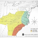
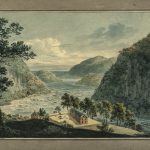
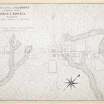
In the fall of 1754, Peter Boehler and Andreas Höger traversed a 100,000-acre tract of land in North Carolina that had recently been acquired by the Moravian Church.[1] The Moravians named their Carolina land “Wachovia.” Boehler, a leader in the Moravian Church, and Höger, a skilled map maker who was also Moravian, were tasked to measure Wachovia and produce a map. Records kept by the Moravians clearly state that Andreas Höger produced a map of Wachovia while he was in North Carolina, but throughout the twentieth century no map had been identified to his hand. In fact, some scholars doubted that the map actually existed. This article reports on the discovery of Höger’s map—an investigation that led to the identification of not one but three maps produced during the short time in 1754 that Peter Boehler and Andreas Höger were in North Carolina. The product of their efforts in Wachovia … Continued